In the ever-evolving landscape of construction and civil engineering, precision is paramount. Survey engineers play a crucial role in ensuring that projects are executed with the utmost accuracy. Two key technologies that have revolutionised the surveying process are Global Navigation Satellite Systems (GNSS) and Total Stations. This article delves into how these tools enhance build accuracy and contribute to the overall success of construction projects, despite the demanding nature of the profession.
Introduction to Survey Engineering
Survey engineering is a cornerstone of modern construction and infrastructure development, leveraging cutting-edge technology to deliver detailed insights and tailored solutions. Engineering surveyors are indispensable in ensuring the accuracy and efficiency of construction projects, from the initial planning stages through to completion. Their expertise spans a wide array of engineering surveying tasks, including digital mapping, laser scanning, and the establishment of control points.
Expert surveyors employ innovative solutions to gather precise data, which supports informed decision-making on construction sites. The advent of digital twins and laser scanning technology has revolutionized the field, allowing professionals to create accurate digital replicas of physical assets. This capability is essential for the successful completion of construction projects, ensuring that buildings and infrastructure are built to exact specifications and within designated boundaries.
The profession of survey engineering demands a diverse skill set. Surveyors must possess a deep knowledge of engineering surveying techniques, digital mapping, and data analysis. Additionally, they must be adept at communicating effectively with other professionals, including engineers, architects, and contractors, to ensure that projects are completed efficiently and to a high standard. This blend of technical expertise and collaborative ability underscores the critical role of survey engineers in the construction industry, driving projects towards successful and precise outcomes.
The Importance of Accuracy in Construction
Accuracy in construction is not merely a matter of aesthetics; it directly impacts the functionality, safety, and longevity of structures. Survey engineers must identify potential issues in designs and structures during civil construction projects to ensure successful outcomes. Errors in measurements can lead to costly reworks, project delays, and even safety hazards. Therefore, survey engineers must employ precise tools and methodologies to ensure that every aspect of a build adheres to the specified standards.
Cost Implications of Inaccuracies
Inaccuracies in construction can lead to significant financial repercussions. When a project requires rework due to measurement errors, it is crucial to evaluate surveying, spatial, and related information to prevent costs from escalating rapidly. This not only affects the immediate budget but can also impact the overall timeline of the project, leading to further financial strain. By utilising advanced technologies such as GNSS and Total Stations, survey engineers can mitigate these risks, ensuring that projects are completed on time and within budget.
Moreover, the financial burden of inaccuracies extends beyond the immediate project costs. Stakeholders may face penalties for delays, and the reputation of the construction firm can suffer, leading to lost future contracts. In an industry where trust and reliability are paramount, maintaining a record of precision can significantly enhance a company’s standing. Additionally, investing in training for staff on the latest surveying technologies can yield long-term savings by reducing the likelihood of errors and fostering a culture of accuracy within the workforce.
Safety Considerations
Beyond financial implications, inaccuracies can pose serious safety risks. Structural failures due to improper measurements can endanger lives and lead to catastrophic consequences. Survey engineers, therefore, have a moral and professional obligation to ensure that their measurements are as precise as possible. The integration of GNSS and Total Stations into the surveying process enhances safety by providing reliable data that informs critical decisions throughout the construction process.
Furthermore, the importance of safety in construction cannot be overstated, as it encompasses not only the workers on-site but also the general public who may be affected by the structures being built. For instance, a miscalculation in the load-bearing capacity of a beam can lead to disastrous outcomes, such as collapses or severe structural damage. Regular audits and adherence to stringent safety protocols are essential in reinforcing the commitment to accuracy. By fostering a proactive approach to safety, construction firms can create a secure environment that prioritises the well-being of everyone involved, thereby enhancing the overall integrity of their projects. Safety protocols should be adaptable in accordance with the evolving requirements of each project.
Understanding GNSS Technology
Global Navigation Satellite Systems (GNSS) encompass a range of satellite systems that provide geolocation and time information to a GNSS receiver anywhere on Earth. These systems ensure interdisciplinary access to project data, allowing all stakeholders to utilise the same accurate geographical information. The most well-known of these systems is the Global Positioning System (GPS), but there are others, including GLONASS, Galileo, and BeiDou. Survey engineers leverage GNSS technology to achieve high levels of accuracy in their work.
How GNSS Works
GNSS operates by using a method of triangulating signals from multiple satellites. A GNSS receiver calculates its position by measuring the time it takes for signals from satellites to reach it. By using at least four satellites, the receiver can determine its precise location in three-dimensional space. This technology allows survey engineers to gather accurate data over large areas quickly, making it invaluable for construction projects.
Applications of GNSS in Surveying
Survey engineers use GNSS for a variety of applications in different locations, including site surveys, topographic mapping, and monitoring land movement. The ability to obtain precise measurements in real-time enables engineers to make informed decisions on-site, reducing the likelihood of errors. Furthermore, GNSS technology is particularly beneficial for large-scale projects, where traditional surveying methods may be time-consuming and less accurate.
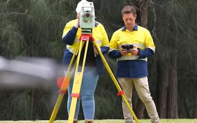
The Role of Total Stations
Total Stations are another essential tool in the survey engineer’s arsenal. They assist in the execution of construction surveys by providing support and verification to ensure accuracy and proper documentation. Combining the functions of a theodolite and an electronic distance measuring device, Total Stations provide a comprehensive solution for measuring angles and distances with remarkable precision. These instruments are particularly effective for detailed measurements in construction settings.
How Total Stations Operate
Total Stations use a combination of electronic and optical technology to measure distances and angles. By emitting a laser beam to a target and measuring the time it takes for the beam to return, the Total Station can calculate the distance with high accuracy. Additionally, the instrument can measure horizontal and vertical angles, allowing survey engineers to create detailed three-dimensional models of the construction site. Attention to detail is crucial in this process, as it ensures the accuracy and reliability of the measurements.
Advantages of Using Total Stations
The primary advantage of Total Stations is their ability to provide precise measurements in real-time. This immediacy allows survey engineers to review data and adjust their plans, making necessary corrections on the spot, minimising the risk of errors. Furthermore, Total Stations can store data electronically, facilitating easier data management and analysis. This is particularly beneficial in complex projects where multiple measurements are required.
Integrating GNSS and Total Stations for Enhanced Accuracy
The integration of GNSS and Total Stations offers a powerful combination that significantly enhances build accuracy. Collaboration between these technologies ensures improved project outcomes by reducing errors and better managing operational risks throughout the project lifecycle. While GNSS provides a broad overview of the site and its geographical context, Total Stations allow for detailed measurements and adjustments. Together, these technologies create a comprehensive surveying solution that meets the demands of modern construction projects.
Creating a Seamless Workflow
When survey engineers utilise both GNSS and Total Stations, they can create a seamless workflow that enhances operations, improving efficiency and accuracy. For instance, GNSS can be used to establish control points across a site, which can then be referenced by Total Stations for more detailed measurements. This synergy not only speeds up the surveying process but also ensures that all measurements are consistent and reliable.
Case Studies of Successful Integration
Numerous construction projects have demonstrated the effectiveness of integrating GNSS and Total Stations. For example, large infrastructure projects, such as bridges and highways, often require precise measurements over extensive areas. By employing both technologies, land surveyors in Sydney have been able to achieve remarkable accuracy, ensuring that these critical structures are built to last. These case studies serve as a testament to the potential of combining GNSS and Total Stations in the field.
Challenges and Considerations
While GNSS and Total Stations offer significant advantages, survey engineers must also be aware of the challenges associated with these technologies. Certified professionals must maintain their certifications by undertaking Continuing Professional Development (CPD) and paying an annual renewal fee to ensure their certification remains valid and recognized within the geospatial sector. Factors such as signal interference, environmental conditions, and equipment limitations can impact the accuracy of measurements. Understanding these challenges is essential for survey engineers to maximise the effectiveness of their tools.
Signal Interference and Limitations
GNSS signals can be affected by various factors, including buildings, trees, and atmospheric conditions. In urban environments, for example, signal multipath can occur when signals bounce off structures, leading to inaccuracies. Survey engineers must be adept at recognising these limitations and adjusting their methods accordingly. This might involve using additional reference stations or employing correction techniques to enhance accuracy. Effective management of resources is also crucial in mitigating these challenges and ensuring precise results.
Training and Expertise
The successful implementation of GNSS and Total Stations requires a skilled workforce with the required skills. Survey engineers must receive adequate training in both the technology and the methodologies associated with these tools. Continuous professional development is essential to keep pace with advancements in technology and ensure that survey engineers can leverage these tools effectively.
The Future of Surveying Technology
The future of surveying technology is bright, with ongoing advancements promising to enhance the capabilities of GNSS and Total Stations further. Educational programs, such as the UniReady Enabling Program, play a crucial role in preparing students to meet the evolving demands of the industry. Innovations such as real-time kinematic (RTK) positioning and advancements in data processing software are set to revolutionise the industry, offering even greater accuracy and efficiency.
Emerging Technologies
Emerging technologies, such as drone surveying and mobile mapping systems, are also beginning to complement traditional surveying methods. Drones equipped with GNSS technology can cover large areas quickly, capturing high-resolution images and data that can be integrated with Total Station measurements. This synergy between different technologies will continue to shape the future of surveying, making it more efficient and accurate than ever before.
Conclusion
In conclusion, the integration of GNSS and Total Stations has transformed the landscape of surveying, enabling survey engineers to improve build accuracy significantly. By understanding the importance of precision in construction, utilising advanced technologies, and addressing the challenges associated with these tools, survey engineers can ensure the success of their projects. Providing the necessary support and resources is crucial in guiding engineering surveyors through complex decision-making processes. As technology continues to evolve, the potential for even greater accuracy and efficiency in surveying will undoubtedly shape the future of the construction industry.