Cadastral and detail surveys are essential components of successful property management and development in Sydney. This article dispels common misconceptions, outlines processes, and discusses the vital roles played by Sydney surveyors in these undertakings. Understanding these aspects can facilitate better decision-making for property owners, developers, and investors alike.
Understanding the basics of cadastral and detail surveys
To comprehend the significance of cadastral and detail surveys, one must first grasp their foundational principles. Cadastral surveys are critical for defining property boundaries and ownership rights, while detail surveys provide intricate details, such as topography and existing infrastructure.
What is a cadastral survey?
A cadastral survey is a precise measurement and mapping of land parcels. Conducted to establish the legal boundaries of properties, these surveys are crucial for property transactions, land use planning, and resolving disputes. Surveyors use advanced technology and techniques to ensure accuracy, often marking boundary lines with physical markers.
This type of survey is recorded in government property registers, serving as a public record that protects property owners’ rights. In Sydney, cadastral surveys adhere to strict legislative and regulatory frameworks to maintain uniformity and reliability. The process involves meticulous planning and execution, often requiring surveyors to collaborate with local authorities to ensure compliance with zoning laws and land use regulations. This collaboration is vital, as it helps to prevent potential legal issues that may arise from boundary disputes or misinterpretations of land ownership.
The importance of detail surveys
Detail surveys, on the other hand, enable a comprehensive understanding of the physical attributes of land. They map significant features such as contours, trees, buildings, and utility lines, which are crucial when planning construction projects or renovations.
By providing exact measurements and visual representations, detail surveys facilitate better design and construction decisions, significantly reducing risks associated with land development. They are indispensable tools for architects, engineers, and planners aiming to optimise land use. Furthermore, detail surveys often incorporate advanced technologies such as Geographic Information Systems (GIS) and 3D modelling, allowing for a more dynamic analysis of the land. This technological integration not only enhances the accuracy of the data collected but also enables stakeholders to visualise potential developments in a more interactive manner, fostering better communication and understanding among all parties involved in a project.
The process of cadastral and detail surveys in Sydney
The process of undertaking cadastral and detail surveys involves several systematic steps that ensure accuracy and compliance with regulatory requirements. Each stage plays a crucial role in delivering reliable results to clients and stakeholders.
Initial research and planning
The survey process begins with extensive research to gather essential information about the land. This includes examining existing survey documents, historical data, and relevant property registries. Knowledge of surrounding areas and local regulations is also vital during this stage.
Planning establishes the direction for the survey, determining the specific objectives and methods to be utilised. It sets the groundwork for the subsequent fieldwork and data collection phases, ensuring a streamlined survey process. This initial phase often involves consultations with local authorities, which can provide insights into any upcoming developments or changes in zoning laws that may affect the land. Additionally, understanding the historical context of the property can reveal potential issues that may arise during the survey, such as unresolved boundary disputes or easements that have not been properly documented.
Fieldwork and data collection
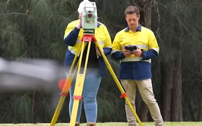
Fieldwork is where the theoretical plans materialise into actionable results. Surveyors move onto the land, employing precise equipment such as total stations and GPS devices to collect data. The accuracy of this phase is paramount, as any discrepancies can lead to boundary disputes or problematic constructions.
During fieldwork, surveyors document critical information, including geographical features and existing infrastructure. The data collected informs the final survey report, providing clarity and detail about the land in question. Notably, surveyors also pay close attention to environmental factors, such as soil type and drainage patterns, which can significantly influence land use and development potential. This thorough approach ensures that all aspects of the land are considered, allowing for a more comprehensive understanding of its capabilities and limitations.
Analysis and final report
After the fieldwork, the data collected undergoes rigorous analysis. Surveyors integrate the raw data into comprehensive maps and reports that reflect the findings with utmost clarity. This final report not only delineates property boundaries but also features essential topographical information.
Clients receive these reports, which serve as official documentation for any further legal or development activities. The accuracy and objectivity of the analysis are crucial, as they uphold the integrity of the entire survey process. Furthermore, these reports often include recommendations for future land use, taking into account both current regulations and potential changes in the area. This foresight can be invaluable for clients looking to maximise the value of their property, as it provides a clear pathway for development while ensuring compliance with local planning laws and environmental considerations.
The role of surveyors in cadastral and detail surveys
Surveyors are the backbone of cadastral and detail surveys, bringing a wealth of expertise to the field. Their qualifications and skills are essential in guaranteeing that surveys are conducted accurately and effectively, navigating both legal and practical expectations.
Qualifications and skills of a professional surveyor
To become a professional surveyor in Sydney, one typically must complete formal education in surveying or a related field, accompanied by practical training. Many surveyors in Sydney also hold accredited certifications recognised by professional bodies, ensuring adherence to industry standards.
In addition to technical skills, surveyors need excellent analytical and problem-solving abilities, as they often face complex challenges during their work. Familiarity with technological tools, software, and regulations is equally crucial, allowing surveyors to perform with precision in an evolving industry. Moreover, the ability to interpret geographical data and apply it to real-world scenarios is vital, as it enables surveyors to provide clients with actionable insights and recommendations based on their findings.
Responsibilities of a surveyor during the survey process
Surveyors bear the responsibility of executing surveys with a high degree of professionalism and ethics. This includes ensuring all measurements are accurate, interpreting data correctly, and maintaining open communication with clients throughout the process.
Additionally, they are tasked with preparing thorough reports that stand up to scrutiny during legal or administrative reviews. This responsibility is paramount, as their findings can significantly affect property rights and potential projects. Surveyors must also stay abreast of changes in legislation and land use policies, as these can impact their work and the advice they provide to clients. Their role often extends beyond the survey itself; they may also engage in negotiations regarding land disputes or assist in the planning stages of development projects, ensuring that all necessary regulations are adhered to and that the interests of all parties are considered.
Legal aspects of cadastral and detail surveys
Understanding the legal implications of cadastral and detail surveys is vital for property owners and developers. These surveys are not just technical undertakings; they also play critical roles in property rights and ownership legality.
Property rights and land ownership
Cadastral surveys legally define property boundaries, establishing ownership rights that are recognised by law. They protect owners from encroachments and ambiguous claims, reinforcing the importance of conducting a professional survey when purchasing or developing land.
In Sydney, cadastral surveys are fundamental to the effective management of land resources, ensuring that development projects comply with local planning frameworks. They also assist in reinforcing local governance by providing clarity on land usage and ownership.
Boundary disputes and resolutions
Boundary disputes frequently arise in property dealings, often leading to costly legal battles. Cadastral surveys can delineate precise boundaries, providing definitive evidence for resolving such disputes. By offering clear documentation of property lines, surveys help adjudicate conflicts diplomatically.
When community disputes arise over land usage or boundaries, professional surveyors can mediate and provide insights to help stakeholders understand their rights and responsibilities, establishing a basis for amicable resolutions.
Costs and considerations for cadastral and detail surveys
The financial investment required for cadastral and detail surveys can vary widely and be influenced by several factors. Understanding these costs allows property owners and developers to plan accordingly, ensuring they have the appropriate budget for these essential services.
Factors influencing the cost of surveys
Costs are influenced by the survey’s complexity, the property’s size, and the specific requirements set forth by local regulations. Additional factors include accessibility to the site, the level of detail required, and the surveyor’s experience.
It is wise to gather detailed quotes from multiple surveying firms to ensure transparency and comparability. A thorough understanding of the services included can clarify costs and prevent unexpected expenses.
Preparing for a cadastral or detail survey
To optimise the surveying process, property owners should prepare adequately. This includes gathering relevant documentation, such as existing property deeds, previous surveys, and local planning documents.
Communicating with the surveyor beforehand about any concerns or specific objectives for the survey can also streamline the process. Engaging in this preparatory work not only aids the surveyor but also contributes positively to the success of the project.
In conclusion, comprehending the intricacies of cadastral and detail surveys in Sydney is essential for anyone involved in property ownership, management, or development. By understanding their significance, processes, and the roles played by Sydney surveyors, stakeholders can navigate the complex landscape of property transactions with confidence and clarity.