When it comes to planning an excavation project, proper preparation is essential. One vital aspect that often gets overlooked is utility mapping. This article delves into the importance of utility mapping, the risks associated with neglecting this crucial step, and the benefits of professional utility mapping services. As you will see, investing in utility mapping can save both time and resources while ensuring the safety of workers and the general public.
Understanding the Importance of Utility Mapping
Utility mapping is the process of identifying and documenting the location of underground utilities such as gas lines, water pipes, electrical cables, and sewer systems. This step is fundamental in preventing potential hazards that may arise during excavation. By understanding the layout of these utilities, construction teams can make informed decisions, minimising risks during the excavation process.
The primary purpose of utility mapping is to provide a detailed representation of what lies beneath the surface, allowing engineers and contractors to plan their projects accordingly. Additionally, it provides necessary information for maintenance and future developments, helping to preserve existing infrastructure.
Defining Utility Mapping and Its Purpose
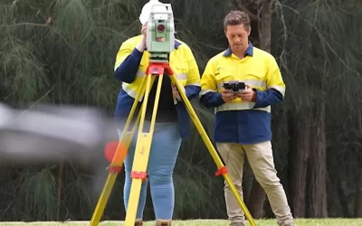
Utility mapping employs various techniques to determine the location of underground utilities. This can range from electromagnetic location, ground-penetrating radar, to land surveying by experienced professionals. Each method has its advantages, and the context of the project will often dictate which technique is most appropriate.
The purpose of utility mapping goes beyond mere identification; it aims to safeguard against unintentional damage to crucial infrastructures, which can pose significant risks to safety and contribute to costly delays. Understanding the utilities present allows for a more efficient and focused excavation approach.
The Role of Utility Mapping in Excavation Projects
In excavation projects, the role of utility mapping is paramount. Not only does it provide a clear depiction of underground utilities, but it also enhances communication among the project team. Knowing precisely where to excavate reduces the chances of miscommunication that could lead to dangerous encounters with live utilities.
Moreover, utility mapping can also be a legal requirement in many areas. Failing to conduct proper mapping may leave contractors liable for accidents and damages, further highlighting the importance of including this step in project planning.
Additionally, the integration of advanced technologies in utility mapping has revolutionised the way these assessments are conducted. For instance, the use of Geographic Information Systems (GIS) allows for the visualisation and analysis of utility data in a spatial context, enabling teams to understand the relationships between various utilities and their surroundings. This not only aids in immediate project planning but also serves as a valuable resource for future developments and urban planning initiatives.
Furthermore, as cities expand and develop, the complexity of underground utilities increases. Utility mapping becomes essential not just for current projects but also for long-term urban management. By maintaining an accurate and updated record of underground utilities, municipalities can better plan for infrastructure upgrades, emergency responses, and even environmental assessments, ensuring that urban growth is sustainable and safe for all residents.
The Risks of Neglecting Utility Mapping
Ignoring utility mapping can lead to a multitude of risks that can derail an excavation project. These risks are not merely theoretical; they pose real hazards that can affect worker safety and project success. Let us examine some of these risks more closely.
Potential Hazards of Uncharted Utilities
Working with uncharted utilities can lead to disastrous outcomes, including explosions, water main breaks, and electrical failures. These hazards can result in severe injuries or even fatalities if not properly managed. Furthermore, the presence of unmarked utilities can create confusion during excavation, putting workers and nearby residents at risk.
Additionally, unexpected encounters with underground systems may necessitate emergency services, diverting resources from the project and delaying progress. Such incidents not only incur extra expenses but can also have an impact on the local community. The disruption caused by these unforeseen events can lead to traffic congestion, water supply interruptions, and even power outages, affecting not just the immediate area but also surrounding neighbourhoods. This ripple effect can foster resentment among residents, who may feel the burden of the project’s mismanagement.
Financial Implications of Accidental Utility Damage
The financial repercussions of accidental utility damage are considerable. A single incident can lead to repair costs, legal fees, and potential fines, all of which can escalate quickly. The loss of productivity caused by project delays may also affect project timelines and budgets, leading to further complications.
Additionally, the reputation of the contracting company may suffer if they are perceived as careless or unprofessional. This can create long-term consequences that affect future business opportunities. Companies may find themselves facing increased insurance premiums or difficulty securing contracts, as clients become wary of potential risks associated with unprofessional practices. Furthermore, the financial stakes involved in utility mapping cannot be understated; investing in proper mapping technologies and training can ultimately save companies from the far greater costs associated with accidents and their aftermath.
The Process of Professional Utility Mapping
Understanding how professional utility mapping works can provide invaluable insights into its significance. This process involves a series of steps that ensure accurate and reliable results, utilising advanced technology to achieve the best outcomes.
The Technology Behind Utility Mapping
Various technologies play a crucial role in utility mapping. Techniques such as ground-penetrating radar (GPR) and electromagnetic induction are often employed to ensure comprehensive surveys. GPR uses radar pulses to image the subsurface, while electromagnetic induction detects metallic utilities using magnetic fields.
These advanced techniques allow for precise location mapping, significantly reducing the margin for error. The adoption of modern technology in utility mapping not only enhances accuracy but also improves the overall safety of excavation projects. Furthermore, the integration of Geographic Information Systems (GIS) with utility mapping technology enables professionals to visualise and analyse spatial data effectively. This synergy allows for better decision-making and planning, ensuring that all stakeholders have access to crucial information regarding the utility landscape of a given area.
Steps Involved in a Comprehensive Utility Survey
A thorough utility survey typically includes several key steps. Initially, project planners will assess the site and gather existing information about the utility layout. Following this, a combination of preliminary site visits and advanced mapping tools is used to accurately portray the underground utilities.
Once the data collection is complete, experienced professionals will analyse the results and create a detailed report, including maps and recommendations. This report can serve as a vital guide during excavation, informing the team about specific locations that require care and attention. Additionally, the process often involves engaging with local utility companies to verify the accuracy of the data collected. This collaboration is essential, as it helps to cross-check existing utility records and ensures that any potential discrepancies are addressed before excavation begins. By fostering communication between various stakeholders, the utility mapping process not only enhances safety but also promotes a more efficient workflow, ultimately leading to successful project outcomes.
The Benefits of Professional Utility Mapping
Engaging a professional utility mapping service provides numerous benefits, making it a wise investment for any excavation project. By prioritising safety and efficiency, businesses can yield significant returns on their investment.
Enhancing Safety Measures with Utility Mapping
The foremost benefit of professional utility mapping is the enhancement of safety measures. By clearly identifying and mapping out underground utilities, workers can proceed with a detailed understanding of risks, thereby reducing the potential of hazardous incidents occurring during excavation.
Furthermore, having accurate maps allows for better planning and positioning of equipment, ensuring that the worksite remains safe and conducive to productivity. This focus on safety not only protects the workers but also addresses concerns from the local community, fostering a sense of trust and accountability.
Cost-saving Aspects of Utility Mapping
Utility mapping is ultimately a cost-saving measure. By preventing unexpected occurrences of utility damage, companies can mitigate financial losses and avoid unnecessary project delays. The investment in utility mapping often pays for itself when one considers the potential costs associated with accidents and damages.
Additionally, efficient project management and fewer disruptions can lead to smoother operations, greater productivity, and enhanced customer satisfaction. Choosing professional utility mapping services can significantly improve the overall outcome of excavation projects.
Choosing the Right Utility Mapping Service
With various utility mapping services available, selecting the right one requires careful consideration. The success of your excavation project hinges on engaging a reliable and proficient service provider who understands your unique needs.
Key Factors to Consider When Hiring a Utility Mapping Professional
When evaluating potential utility mapping professionals, it is essential to consider factors such as experience, reputation, and technology used. Experienced professionals often have a proven track record and can offer insights based on previous projects.
Moreover, the reputation of a company can provide assurances of reliability and competence. Researching customer reviews and seeking recommendations can help in establishing trust in their services. Additionally, understanding the technology employed can offer insight into the accuracy and efficiency of their methods.
Understanding the Credentials of a Reliable Utility Mapping Company
The credentials of your chosen utility mapping company play a pivotal role in ensuring quality outcomes. Look for certifications, industry affiliations, and demonstrated expertise in utility mapping and surveying. Accredited professionals often adhere to the highest standards, reinforcing the safety and reliability of their services.
In conclusion, better educated decisions about utility mapping can lead to successful excavation projects, enhanced safety, and substantial cost savings. By understanding the importance of hiring a professional utility mapping service, you can safeguard your project against potential hazards and ensure a seamless excavation experience.