Construction surveying is a crucial aspect of the building process, ensuring that projects are executed with precision and accuracy. Construction surveying services are essential for various types of surveys required during the construction process, ensuring projects adhere to approved plans and regulations. In Sydney, where the skyline is constantly evolving, construction surveyors rely on a variety of advanced tools to ensure that every measurement is spot on. This article delves into the essential tools used by construction surveyors in Sydney, highlighting their importance and functionality in modern construction projects.
Introduction to Construction Surveying
Construction surveying is a critical component of the construction industry, playing a vital role in ensuring that construction projects are completed accurately, efficiently, and safely. Construction surveyors are responsible for providing dimensional control for all stages of construction work, from the initial planning and design phase to the final completion of the project. They use various techniques and equipment, including surveying instruments and software, to gather and analyse data on construction projects. The primary purpose of construction surveying is to provide accurate measurements and data to inform decision-making and ensure that construction work is carried out in accordance with design specifications and building regulations.
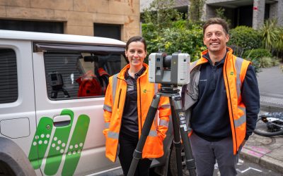
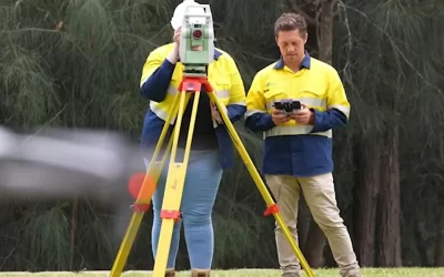
1. Total Stations
Total stations are one of the most vital tools in a construction surveyor’s arsenal. Building surveying, which requires specific qualifications and responsibilities, plays a crucial role in ensuring compliance with safety regulations and standards during the construction process in Victoria. These electronic devices combine the functions of a theodolite and an electronic distance measuring (EDM) instrument. They allow surveyors to measure angles and distances with remarkable accuracy, making them indispensable for site layout and boundary determination.
Precision and Efficiency
The precision offered by total stations is unparalleled. By incorporating key elements such as the ability to measure angles to within seconds and distances to millimetres, they ensure the accuracy needed for complex projects. This level of detail is crucial in urban environments like Sydney, where even the slightest miscalculation can lead to significant issues down the line.
Moreover, total stations enhance efficiency on site. Many models come equipped with data collection capabilities, allowing surveyors to store measurements directly on the device. This eliminates the need for manual recording and reduces the chances of human error, streamlining the workflow considerably.
Integration with Software
Modern total stations can be integrated with advanced surveying software, allowing for real-time data analysis and visualisation. In the field of engineering, precise data is crucial to prevent costly setbacks and safety issues. This integration enables surveyors to create detailed site plans and models, which can be shared with architects and engineers instantly. In a fast-paced construction environment, this capability is invaluable, facilitating better communication and collaboration among all parties involved.
2. GPS Surveying Equipment
Global Positioning System (GPS) technology has revolutionised the field of surveying, especially on a construction site where accurate location data is crucial. GPS surveying equipment allows for the determination of precise locations on the Earth’s surface, which is particularly useful in large-scale projects where traditional methods may be impractical.
Benefits of GPS Technology
The primary advantage of GPS surveying is its ability to provide accurate location data over vast areas. This is especially beneficial in Sydney, where construction sites can span several hectares. GPS equipment can quickly establish control points, which serve as reference markers for subsequent measurements. For new infrastructure projects, GPS is crucial in developing essential services such as roads, sewers, and stormwater management in new construction projects.
Additionally, GPS technology is highly effective in areas where visibility is limited, such as dense urban environments. Unlike traditional methods that require a clear line of sight, GPS can function effectively even in challenging conditions, making it a reliable choice for surveyors working in the heart of the city.
Real-Time Kinematic (RTK) GPS
For even greater accuracy, surveyors often utilise Real-Time Kinematic (RTK) GPS systems. RTK technology enhances the precision of standard GPS measurements by providing real-time corrections, allowing for centimetre-level accuracy. This is particularly beneficial for tasks such as staking out building corners or aligning structures, where precision is paramount. RTK GPS systems also help verify that structures are built according to approved plans, ensuring compliance and accuracy in construction projects.
3. Laser Scanners
Laser scanning technology has emerged as a game-changer in the surveying industry. Accurate construction survey data is crucial for ensuring project accuracy and safety, preventing costly disruptions and misalignments. These devices capture detailed 3D representations of physical spaces, providing surveyors with invaluable data for analysis and planning.
3D Modelling and Visualisation
The ability to create 3D models from laser scans allows for a comprehensive understanding of a site’s topography and existing structures. A boundary survey is crucial for identifying and confirming the exact boundaries of a property, ensuring that construction adheres to legal property lines and approved plans. This is particularly useful in Sydney, where many construction projects involve working around existing buildings and infrastructure. By generating accurate models, surveyors can identify potential challenges and plan accordingly, minimising disruptions during construction.
Furthermore, laser scanning enhances visualisation for all stakeholders. Architects, engineers, and clients can view the scanned data in an interactive format, facilitating better decision-making and collaboration throughout the project lifecycle.
Speed and Safety
Laser scanners also significantly speed up the surveying process. A single scan can capture millions of data points in a matter of minutes, allowing surveyors to complete their work quickly and efficiently. This is particularly advantageous in busy urban areas, where time is often of the essence.
Moreover, laser scanning reduces the need for surveyors to physically access potentially hazardous areas. By capturing data remotely, surveyors can ensure their safety while still obtaining the necessary information for accurate measurements.
4. Digital Levels
Digital levels are essential tools for construction surveyors, providing precise measurements of height differences across a site. The accuracy and ease of use of these instruments can vary based on a range of factors such as the quality of the device, the user’s skills, environmental conditions, and the specific requirements of the project management. These instruments are particularly useful for establishing benchmarks and ensuring that structures are built to the correct elevation.
Accuracy and Ease of Use
Digital levels offer enhanced accuracy compared to traditional optical levels. They utilise electronic sensors to measure height differences, significantly reducing the potential for human error. Employer support is crucial in using these advanced surveying tools effectively. This level of precision is crucial in construction, where even minor discrepancies can lead to costly adjustments later on.
Additionally, digital levels are user-friendly, often featuring intuitive interfaces that make them accessible to surveyors of all experience levels. This ease of use allows for quicker training and onboarding of new staff, ensuring that projects can progress smoothly.
Data Recording and Analysis
Many modern digital levels come equipped with data recording capabilities, allowing surveyors to store measurements directly on the device. This feature not only streamlines the recording process but also facilitates easier data analysis. Surveyors can quickly review and assess elevation data, making it simpler to identify any discrepancies that may arise during construction. Digital levels help verify accurate measurements, ensuring that the construction adheres to the approved plans.
5. Drones in Surveying
The advent of drone technology has transformed the way construction surveyors operate. Drones are now integral to various surveying services, including residential, civil, and commercial set out surveys, ensuring projects are executed following approved plans. Drones equipped with high-resolution cameras and sensors can capture aerial imagery and data, providing a unique perspective on construction sites.
Aerial Surveys and Mapping
Drones enable surveyors to conduct aerial surveys quickly and efficiently in relation to existing plans. By capturing images from above, they can create detailed maps and models of a site, providing a comprehensive overview of the area. This is particularly beneficial for large projects in Sydney, where traditional surveying methods may be time-consuming and labour-intensive.
Furthermore, aerial surveys allow for the identification of potential issues that may not be visible from the ground. Surveyors can spot discrepancies in terrain, assess vegetation cover, and even monitor construction progress from a bird’s-eye view, enhancing their ability to manage projects effectively.
Cost-Effectiveness and Accessibility
Using drones for surveying can significantly reduce costs associated with traditional methods. Various factors such as the type of drone, the complexity of the terrain, the skills of the operator, and the specific requirements of the project influence the cost and efficiency of using drones in surveying. The speed at which drones can cover large areas means that projects can be completed more quickly, saving both time and money. Additionally, drones can access difficult-to-reach locations, eliminating the need for scaffolding or other equipment that may be required for traditional surveying.
6. Software Solutions for Surveying
In addition to physical tools, software solutions play a crucial role in modern construction surveying. From data analysis to project management, various software applications help surveyors streamline their processes and improve accuracy.
Data Management and Analysis
Surveying software allows for the efficient management of data collected from various instruments. This software can process and analyse measurements, generating reports and visualisations that aid in decision-making. By centralising data, surveyors can ensure that all stakeholders have access to the information they need, fostering collaboration and transparency.
Project Management Tools
Many surveying software solutions also include project management features, enabling surveyors to track progress, manage timelines, and allocate resources effectively. These tools provide essential support for project management and resource allocation, ensuring that surveyors can handle complex tasks efficiently. This is particularly beneficial in fast-paced environments like Sydney, where multiple projects may be underway simultaneously. By utilising these tools, surveyors can ensure that projects stay on track and within budget.
Role of a Surveyor
A surveyor plays a critical role in the construction process, working closely with architects, engineers, and other stakeholders to ensure that construction projects are completed successfully. Surveyors are responsible for conducting site surveys, verifying property boundaries, and determining the location of existing buildings and infrastructure. They also provide advice on construction design, ensuring that new buildings and infrastructure are constructed in accordance with regulations and design specifications. In addition, surveyors are involved in the planning and management of construction projects, helping to ensure that projects are completed on time, within budget, and to the required quality standards.
Industry Trends
The construction industry is constantly evolving, with new technologies and innovations emerging all the time. One of the current trends in the industry is the use of building information modeling (BIM) and other digital technologies to improve the efficiency and accuracy of construction projects. Another trend is the increasing focus on sustainability and environmental considerations in construction, with many projects incorporating green building materials and energy-efficient design. Construction surveyors must stay up-to-date with these trends and developments in order to provide the best possible services to their clients.
Regulatory Compliance
Construction surveyors must ensure that their work complies with all relevant regulations and standards, including building regulations, zoning laws, and environmental regulations. They must also ensure that their clients are aware of and comply with these regulations, and that all necessary permits and approvals are obtained before construction begins. In Australia, for example, construction surveyors must comply with the Building Code of Australia and other state and territory regulations. Registered building surveyors must also adhere to the standards and guidelines set out by the Australian Institute of Building Surveyors. By ensuring regulatory compliance, construction surveyors can help to prevent delays, cost overruns, and other problems that can arise during construction projects.
Conclusion
The tools used by construction surveyors in Sydney are essential for ensuring accuracy, efficiency, and safety on modern construction sites. From total stations and GPS equipment to laser scanners and drones, each tool plays a vital role in the surveying process. As technology continues to evolve, surveyors must stay abreast of the latest developments to enhance their capabilities and deliver successful projects.
Investing in the right tools not only improves the quality of work but also fosters better collaboration among all stakeholders involved in a construction project. In a dynamic city like Sydney, where construction is ever-present, the importance of effective surveying cannot be overstated. By leveraging these advanced tools, construction surveyors can contribute to the successful execution of projects that shape the future of the city.