What Are the Main Types of Surveyors and What Do They Do?
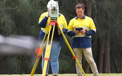
Surveyors perform essential measurements and mapping services across various specialties. These professionals use precise tools and techniques to capture detailed data about properties and terrain.
The main types of surveyors include:
- Land Surveyors: Define legal property boundaries and ownership
- Construction Surveyors: Guide building projects with accurate measurements
- Topographic Surveyors: Map natural and artificial land features
- Hydrographic Surveyors: Survey bodies of water and marine environments
Each type brings specific expertise to different projects. A construction surveyor helps ensure buildings meet design specifications, while a hydrographic surveyor maps underwater terrain for marine projects.
To find a surveyor for your project, identify your specific needs first. This helps match you with a professional who has the right specialisation and experience for your requirements.
What Does a Land Surveyor Specialise In?
Land surveyors are specialists in precise boundary measurements and property mapping. Their expertise extends beyond basic measurements to include:
- Property Boundary Definition: Using GPS technology and advanced surveying equipment to establish exact property lines
- Legal Documentation: Creating detailed maps and reports for property transactions and legal records
- Development Planning: Providing essential data for construction projects and land development
Land surveyors employ sophisticated tools including:
- Total stations
- 3D scanners
- Digital mapping software
- Aerial photography equipment
A land survey serves multiple critical functions:
- Preventing boundary disputes between neighbours
- Supporting planning applications
- Enabling accurate property valuations
- Guiding infrastructure development
These professionals must maintain strict compliance with local council regulations and national surveying standards. Their work directly impacts property rights, real estate transactions, and construction projects across both urban and rural settings.
How Is a Site Surveyor Different from a Land Surveyor?
Site surveyors specialise in detailed assessments of specific construction or development locations. They analyse:
- Ground conditions and soil types
- Existing structures and features
- Site accessibility
- Terrain characteristics
- Underground utilities
- Environmental factors
Land surveyors focus on broader geographical areas, establishing legal boundaries and property lines. Their work encompasses:
- Property boundary determination
- Legal documentation creation
- Title surveys
- Subdivision planning
- Easement mapping
The key distinction lies in their project scope and collaboration patterns. Site surveyors work directly with construction teams, providing crucial data for building projects and development plans. Land surveyors interact primarily with property owners and legal entities, creating documentation for land ownership and boundary disputes.
Both roles require precision and technical expertise, yet their applications serve different purposes in the surveying industry. Site surveyors enable informed construction decisions, while land surveyors safeguard property rights and boundaries.
What Is a Cadastral Surveyor?
Cadastral surveyors, also known as boundary surveyors, are legal specialists who define and document property boundaries with precision. These professionals create authoritative records that establish clear land ownership rights and prevent boundary disputes between neighbouring properties.
Expertise of a Cadastral Surveyor
A cadastral surveyor’s expertise includes:
- Researching historical property records and existing surveys
- Conducting precise field measurements using advanced surveying equipment
- Creating detailed boundary maps with legal descriptions
- Identifying encroachments and easements
- Preparing documentation for land registration
Direct Support Provided by Cadastral Surveyors
Their work directly supports:
- Property transactions and subdivisions
- Local council planning applications
- Boundary dispute resolution
- Land development projects
- Title registration processes
Cadastral surveyors must maintain strict compliance with state regulations and surveying standards to ensure their measurements hold up in legal proceedings. Their detailed maps and documentation serve as official records in land registries and form the basis for property transactions.
What Is an Engineering Surveyor?
Engineering surveyors combine technical knowledge with precise measurement abilities to assist significant construction and infrastructure projects. These experts gather comprehensive information about land features, existing buildings, and underground services.
Key Responsibilities
Their responsibilities involve:
- Marking out construction sites for roads, bridges, and buildings
- Observing changes in structure
- Developing 3D models of the land
- Conducting volume assessments
- Setting up control networks for construction alignment
Tools of the Trade
Engineering surveyors utilise advanced tools such as:
- Total stations
- 3D laser scanners
- GPS systems
- Digital levels
Importance of Their Work
The information they gather assists engineers and architects in making well-informed choices throughout project planning and implementation. Their measurements guarantee that construction activities remain in accordance with design requirements and safety regulations.
A skilled engineering surveyor’s knowledge is extremely valuable for:
- Infrastructure development
- Building construction
- Mining activities
- Industrial installations
- Transportation initiatives
What Is a Construction Surveyor?
Construction surveyors are specialists who perform precise measurements during building projects to ensure accurate layout and positioning of structures. Their expertise lies in translating architectural plans into real-world coordinates on construction sites.
A typical day for a construction surveyor includes:
- Setting out building corners and structural elements
- Verifying foundation depths and positions
- Monitoring construction progress against design specifications
- Checking vertical alignment of walls and columns
- Recording as-built measurements
These professionals use advanced equipment like robotic total stations, GPS systems, and 3D laser scanners to achieve millimetre-level accuracy. Their work directly impacts the quality and safety of construction projects.
Construction surveyors act as a vital link between design teams and construction crews. They interpret technical drawings, provide real-time guidance to builders, and maintain detailed records of construction progress. Their expertise helps prevent costly errors and ensures buildings meet design specifications.
Which Type Of Surveyor Should I Hire For My Next Project?
Looking for a surveyor but still not sure what to choose? Your project requirements dictate the type of surveyor you need. Here’s a quick guide:
- Land Surveyors – Perfect for property boundaries, subdivisions, and legal documentation
- Building Surveyors – Ideal for structural assessments and building compliance
- Engineering Surveyors – Essential for infrastructure and complex construction projects
- Site Surveyors – Best for detailed site analysis and development planning
Local surveyors bring invaluable knowledge of regional regulations and terrain characteristics. Their familiarity with the area ensures accurate, compliant results for your project.
Need help finding the right surveyor? Wumara specialises in matching projects with qualified surveyors across NSW and QLD. Contact us to discuss your project requirements and connect with experienced local surveyors who understand your specific needs.