Waterfront property development in Sydney is a complex process that involves multiple stakeholders, stringent regulations, and a variety of environmental considerations. Among these stakeholders, the role of a surveyor is crucial. Surveyors are responsible for ensuring that development projects are feasible, compliant with local laws, and environmentally sustainable. Surveyors play a crucial role in land development projects, ensuring that all aspects of the development are feasible, compliant with regulations, and environmentally sustainable. This article delves into the essential functions of a Sydney surveyor in the context of waterfront property development.
Introduction to Land Surveying
Land surveying is a cornerstone of any land development project, laying the groundwork for construction, property transactions, and various land-related activities. A land survey involves a meticulous examination of a parcel of land to determine its boundaries, topography, and other physical characteristics. This critical information enables architects, engineers, and property owners to make well-informed decisions regarding land use, development, and management. In Sydney, the demand for land surveying services is particularly high, underscoring the importance of collaborating with licensed surveyors who possess the expertise and experience to deliver precise and dependable results.
Setting a Solid Foundation
Surveying services are indispensable in establishing a solid foundation for any land development project. A comprehensive land survey provides detailed insights into property boundaries, topographical features, and other essential physical attributes. This data is crucial for architects and engineers as they design and plan construction projects, ensuring that all aspects of the development are feasible and compliant with regulations. In the bustling city of Sydney, where land development is a constant, the role of professional land surveying services cannot be overstated. Licensed surveyors bring a wealth of knowledge and experience, ensuring that every project starts on the right foot with accurate and reliable land surveys.
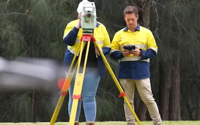
Understanding the Role of a Surveyor
Land surveyors play a vital role in the property development process. Their expertise encompasses land measurement, boundary determination, and the assessment of site conditions. In the context of waterfront properties, their responsibilities expand to include additional factors such as tidal influences, erosion, and environmental protection.
Land Surveys, Measurement, and Boundary Determination
One of the primary responsibilities of a surveyor is to accurately measure land and establish property boundaries through a boundary survey. This is particularly important in waterfront development, where boundaries may be influenced by natural features such as rivers, lakes, or the ocean. Surveyors use advanced technology, including GPS and laser scanning, to ensure precise measurements.
Boundary surveys are essential for accurately determining property lines and preventing legal disputes, providing clarity and legal protection for property owners. Establishing clear boundaries helps prevent disputes between neighbouring property owners and ensures that developers adhere to zoning laws. In Sydney, where waterfront properties are highly sought after, the accuracy of boundary determinations can significantly impact the value and usability of a property.
Site Assessment and Feasibility Studies
Before any development can commence, a thorough site assessment is essential. Surveyors evaluate the topography, soil conditions, and existing infrastructure to determine the feasibility of a project. This assessment is particularly critical for waterfront properties, where factors such as flooding, erosion, and environmental impact must be considered.
A detail survey is crucial for gathering comprehensive information about land features, contours, and elevations, which are critical for architectural design and construction planning.
Feasibility studies conducted by surveyors provide developers with a comprehensive understanding of potential challenges and opportunities. This information is invaluable for making informed decisions about the design and scope of the project, ultimately leading to more successful outcomes.
The Surveying Process
The surveying process is a multi-step procedure that begins with meticulous planning and culminates in the creation of detailed maps and reports. Each phase of the process is designed to ensure that all necessary data is accurately collected and analysed, providing a comprehensive understanding of the land in question.
Initial Planning and Data Processing
The journey of a land surveyor starts with initial planning, where the surveyor meticulously reviews the project requirements and formulates a detailed plan to gather all necessary data. This phase involves determining the type of survey required, selecting the appropriate equipment and technology, and assembling the necessary personnel. Once the plan is set, the surveyor moves on to the fieldwork phase, where data on the land’s physical features, boundaries, and other relevant information is collected. This data collection is performed using advanced tools and techniques to ensure precision.
After the fieldwork, the collected data undergoes processing using specialised software such as AutoCAD. This software helps in creating detailed maps and reports that provide a clear and comprehensive view of the land. At Sydney Surveyor Solutions, our team of experienced surveyors leverages state-of-the-art technology and software to deliver accurate and reliable results, ensuring that our clients have the information they need to make informed decisions.
Regulatory Compliance and Environmental Considerations
Waterfront properties are subject to a myriad of regulations aimed at protecting the environment and ensuring public safety. Surveyors play a key role in navigating these regulations, ensuring that all aspects of a development project comply with local, state, and federal laws. Surveyors provide comprehensive land surveying solutions to ensure that all aspects of a development project comply with local, state, and federal laws.
Navigating Local Regulations
In Sydney, various local councils impose specific regulations on waterfront developments. These may include restrictions on building heights, land use, and environmental protection measures. Sydney land surveyors are well-versed in these regulations and can guide developers through the approval process.
By ensuring compliance with local regulations, surveyors help prevent costly delays and potential legal issues. Their expertise is particularly beneficial in identifying any potential red flags early in the development process, allowing for timely adjustments to project plans.
Environmental Impact Assessments
Given the sensitive nature of waterfront environments, environmental impact assessments (EIAs) are often required for development projects. Surveyors are integral to this process, conducting assessments to evaluate how a proposed development will affect the surrounding ecosystem. A topographic survey is often conducted to measure and map both natural and man-made features of the land, providing essential data for environmental impact assessments.
These assessments consider factors such as water quality, habitat preservation, and the potential for erosion. By identifying potential environmental impacts, surveyors help developers implement strategies to mitigate adverse effects, thereby promoting sustainable development practices.
Collaboration with Other Professionals in Professional Land Surveying Services
The role of a surveyor extends beyond technical measurements and regulatory compliance. They often collaborate with a range of professionals, including architects, engineers, and environmental consultants. This collaboration is essential for ensuring that all aspects of a waterfront development project are aligned. During the construction phase, surveyors provide accurate measurements and monitor land movement to ensure that buildings and infrastructures are constructed correctly.
Working with Architects and Engineers
Surveyors provide critical data to architects and engineers, helping them design structures that are not only aesthetically pleasing but also structurally sound and compliant with regulations. This collaboration is particularly important in waterfront developments, where unique challenges such as flooding and erosion must be addressed.
A construction survey provides precise measurements and sets out construction positions to ensure accuracy in building and infrastructure projects.
By working closely with architects and engineers, surveyors can help ensure that designs are practical and feasible, ultimately leading to more successful projects. Their input can also help streamline the development process, reducing the likelihood of costly redesigns or modifications later on.
Engaging with Environmental Consultants
Given the environmental sensitivities associated with waterfront properties, surveyors often engage with environmental consultants to assess potential impacts and develop mitigation strategies. A contour survey accurately maps land elevation and slopes, providing critical data for architects and civil engineers in planning construction projects and landscape designs. This collaboration ensures that projects adhere to environmental regulations and best practices.
By working together, surveyors and environmental consultants can identify potential issues early in the development process, allowing for proactive measures to be implemented. This not only helps protect the environment but also enhances the overall sustainability of the project.
The Benefits of Working with Licensed Surveyors
Engaging with licensed surveyors offers a multitude of benefits, from competitive pricing to the assurance of quality service. Licensed surveyors bring a level of expertise and experience that is crucial for delivering accurate and reliable results, which can ultimately save clients both time and money.
Competitive Pricing and Quality Service
One of the primary advantages of working with licensed surveyors is the combination of competitive pricing and high-quality service. Licensed surveyors possess the necessary qualifications and certifications, ensuring that their work adheres to the highest standards. This expertise translates into precise and dependable results, which are invaluable for any land development project. At C&A Surveyors, we are committed to providing exceptional service at competitive prices. Our team of licensed surveyors is dedicated to delivering the best possible outcomes for our clients, fostering long-term relationships built on trust, reliability, and outstanding service. By choosing to work with licensed professionals, clients can rest assured that their projects are in capable hands, leading to successful and efficient land development.
Technological Advancements in Surveying
The field of surveying has evolved significantly in recent years, with advancements in technology playing a pivotal role. These innovations have transformed the way surveyors conduct their work, making it more efficient and accurate. Topographic surveys are crucial for providing a comprehensive overview of a site by incorporating features such as elevation and geographical characteristics.
Use of Drones and Aerial Surveying
Drones have become an invaluable tool for surveyors, particularly in waterfront developments. They allow for aerial surveys that can capture detailed images and data over large areas quickly and efficiently. This technology is particularly useful for assessing site conditions, monitoring environmental changes, and conducting topographical surveys.
Detail surveys provide comprehensive assessments of a site’s features, which are crucial for accurate project execution and compliance with local regulations.
By utilising drones, surveyors can provide developers with a comprehensive view of the site, enabling better decision-making and planning. This technology also enhances safety by reducing the need for surveyors to access potentially hazardous areas.
3D Modelling and GIS Technology
Geographic Information Systems (GIS) and 3D modelling software have revolutionised the way surveyors analyse and present data. These tools allow for the visualisation of complex data sets, making it easier for developers to understand site conditions and potential challenges.
With 3D modelling, surveyors can create detailed representations of proposed developments, allowing stakeholders to visualise the project in its entirety. This can be particularly beneficial during the planning and approval stages, as it helps facilitate discussions and decision-making among all parties involved.
Challenges Faced by Sydney Land Surveyors in Waterfront Development
While the role of a surveyor is crucial in waterfront property development, it is not without its challenges. Surveyors in Sydney face a unique set of obstacles that can complicate the development process. Leading land surveyors in Sydney are equipped to handle these challenges, providing quality surveying solutions that ensure successful and compliant development projects.
Environmental Regulations and Restrictions
As mentioned earlier, waterfront properties are subject to stringent environmental regulations. Navigating these regulations can be complex and time-consuming, particularly when multiple agencies are involved. Accurate surveys are essential for the successful execution of land development projects, particularly in areas with stringent environmental regulations. Surveyors must stay up to date with changing laws and policies to ensure compliance.
This can be particularly challenging in Sydney, where environmental concerns are heightened due to the city’s unique coastal ecosystems. Surveyors must balance the needs of developers with the imperative to protect the environment, often requiring creative solutions and compromises.
Community Engagement and Stakeholder Management
Waterfront developments often attract significant public interest, and community engagement is a critical component of the process. Surveyors may be called upon to facilitate discussions with local residents, businesses, and interest groups to address concerns and gather feedback.
Effectively managing stakeholder expectations can be challenging, particularly when there are conflicting interests. Surveyors must possess strong communication skills and be adept at navigating complex social dynamics to ensure that all voices are heard and considered.
The Future of Surveying in Waterfront Development
As Sydney continues to grow and evolve, the role of surveyors in waterfront property development will remain vital. The increasing demand for sustainable and environmentally responsible development practices will require surveyors to adapt and innovate continuously. Future land surveying solutions will need to emphasise precision and reliability to meet these demands.
Emphasis on Sustainability
The future of waterfront development will likely see an even greater emphasis on sustainability. Surveyors will play a key role in ensuring that projects are designed and executed with environmental considerations at the forefront. Surveyors will also be crucial in ensuring that land development projects are designed and executed with environmental considerations at the forefront. This may involve adopting new technologies, implementing best practices, and collaborating closely with environmental experts.
As public awareness of environmental issues grows, developers will increasingly seek out surveyors who can provide innovative solutions that align with sustainable development goals.
Continued Technological Integration
The integration of technology into surveying practices will continue to advance, enabling surveyors to work more efficiently and accurately. As new tools and techniques emerge, surveyors will need to embrace these innovations to remain competitive in the field.
By leveraging technology, surveyors can enhance their ability to provide valuable insights and data to developers, ultimately contributing to the success of waterfront property projects.
Conclusion
The role of a Sydney surveyor in waterfront property development is multifaceted and essential. From land measurement and regulatory compliance to collaboration with other professionals, surveyors ensure that development projects are feasible, sustainable, and compliant with local laws.
As the demand for waterfront properties continues to grow, the expertise of surveyors will be increasingly sought after. By embracing technological advancements and prioritising sustainability, surveyors in Sydney can contribute to the successful development of Sydney’s waterfront, balancing the needs of developers with the imperative to protect the environment.