Boundary disputes are a common issue faced by property owners in Sydney, often leading to tension between neighbours and even legal battles. Understanding the intricacies of property boundaries is crucial for maintaining harmonious relationships and protecting one’s investment. This article delves into the nature of boundary disputes, the role of licensed surveyors, and how the industry experience of Sydney surveyors assists clients in resolving these issues. Surveyors in Sydney work with a diverse range of clients to resolve disputes efficiently and professionally.
Understanding Boundary Disputes
Boundary disputes arise when there is a disagreement between property owners regarding the precise location of their property lines. These disputes can stem from various factors, including unclear property titles, historical changes in land use, or even simple misunderstandings between neighbours. In Sydney, where urban development is rapid and land is at a premium, such disputes can become particularly contentious. Determining the type of survey required is a crucial step in resolving boundary disputes, as it helps clarify the scope and complexity of the issue.
Common Causes of Boundary Disputes
Several factors contribute to boundary disputes in Sydney. One of the most prevalent issues is the lack of clear documentation regarding property boundaries. Many older properties may not have accurate surveys or may rely on outdated plans that no longer reflect the current situation.
Additionally, natural changes in the landscape, such as erosion or the growth of vegetation, can alter the perceived boundaries over time. Furthermore, construction activities, such as building fences or extensions, or changes to buildings or the construction of new buildings, can inadvertently encroach on neighbouring properties, leading to disputes.
The Impact of Boundary Disputes
The implications of boundary disputes can be significant. They can lead to strained relationships between neighbours, increased stress, and even costly legal fees. In some cases, unresolved disputes can result in lengthy court proceedings, which can be detrimental to all parties involved. Therefore, addressing boundary issues promptly and effectively is essential.
Moreover, the emotional toll of boundary disputes should not be underestimated. Neighbours who once enjoyed amicable relationships may find themselves embroiled in conflict, leading to a breakdown in communication and trust. This can create a tense atmosphere not just for the disputing parties, but also for the wider community, as local residents may feel compelled to take sides. The social fabric of neighbourhoods can be significantly affected, with long-term repercussions for community cohesion.
Additionally, the financial implications can extend beyond legal fees. Property values may be adversely affected if a boundary dispute is publicly known, as potential buyers could be deterred by the prospect of ongoing conflicts. This can lead to a vicious cycle where the desire to resolve the dispute is hampered by the fear of financial loss, further entrenching the parties in their positions. As such, it becomes increasingly important for property owners to seek mediation or professional advice to navigate these complex issues before they escalate further.
The Role of a Licensed Surveyor
A licensed surveyor plays a vital role in resolving boundary disputes. Both land surveyors and building surveyors play important roles in resolving property disputes in Sydney, each bringing specialized expertise to building and land-related assessments. Land surveying encompasses a range of services essential for property owners, including boundary, detail, and easement surveys. These professionals are trained to accurately measure and define property boundaries, providing clarity and expert advice to property owners. Their expertise is invaluable in navigating the complexities of land ownership and ensuring compliance with local regulations.
What Does a Licensed Surveyor Do?
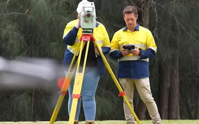
Licensed surveyors conduct detailed land surveys, which involve measuring distances, angles, and elevations to establish the precise boundaries of a property. They utilise advanced technology and equipment, such as GPS and total stations, to gather accurate data. Accuracy is critical in all surveying tasks, as it underpins reliable data, successful project outcomes, and compliance with regulations. This information is then used to create a comprehensive survey plan that outlines the property boundaries clearly.
Surveyors follow a systematic process to collect and analyze data. They ensure accuracy through the use of advanced methods and calibrated equipment, delivering precise measurements that meet client expectations.
In addition to boundary surveys, licensed surveyors can also assist with various other services, including subdivision surveys, easement assessments, engineering surveys, and compliance checks with local zoning laws. Their knowledge of land law and property rights ensures that all aspects of a property are considered during the surveying process. Furthermore, they are adept at interpreting historical land records and maps, which can be crucial in cases where boundary lines have shifted over time due to natural changes or human intervention.
Licensed surveyors have extensive experience in providing surveying services for a variety of projects, including telecommunications and civil infrastructure developments.
Benefits of Engaging a Licensed Surveyor
Engaging a licensed surveyor offers several advantages. Firstly, their expertise can help clarify property boundaries, reducing the likelihood of disputes escalating. By providing an accurate and professional assessment, surveyors can facilitate discussions between neighbours and help reach amicable agreements.
Surveyors tailor their land surveying services to meet the specific needs of each client, taking into account project requirements, terrain complexities, and regulatory considerations. They are also committed to the timely delivery of survey results, ensuring projects proceed efficiently and deadlines are met.
Moreover, having a licensed surveyor’s report can be invaluable in legal proceedings. Courts often rely on expert evidence when adjudicating boundary disputes, and a surveyor’s findings can significantly influence the outcome. This professional endorsement can provide peace of mind to property owners, knowing that their interests are protected. Additionally, licensed surveyors can play a crucial role in property development projects, ensuring that any new constructions or modifications comply with local regulations and do not infringe on neighbouring properties. Their involvement can streamline the planning process, helping to avoid costly delays and ensuring that all necessary permits are obtained before work commences.
Types of Surveys
When it comes to managing property boundaries and supporting land development in Sydney and across New South Wales, choosing the right type of survey is essential. Different projects and legal requirements call for specific surveying services, each designed to provide accurate measurements and detailed information for various purposes. Our team of experienced surveyors offers a comprehensive range of surveying solutions to meet the unique challenges of every project.
Boundary Surveys
Boundary surveys are fundamental for determining the exact location of property boundaries. Whether you’re planning to build, subdivide land, or resolve a boundary dispute, a boundary survey provides the legal documentation and precise measurements needed to protect your investment and ensure compliance with local regulations. These surveys are crucial for land development, construction, and property transactions, helping to prevent costly mistakes and future disputes.
Construction Surveys
Construction surveys provide the accurate measurements and layouts required for building and infrastructure projects. By marking out the exact locations for structures, roads, and utilities, construction surveys help ensure that every element of a project is built according to plan. Our expert surveyors use advanced technology and equipment to deliver timely and reliable results, supporting builders and engineers throughout the construction process.
Topographic Surveys
Topographic surveys focus on mapping the physical features of a site, including elevation changes, vegetation, watercourses, and existing structures. This type of survey is invaluable for architects, engineers, and developers who need a clear understanding of the land’s contours and characteristics before starting a project. Topographic mapping supports effective site investigation, design, and planning, ensuring that construction and landscaping are based on accurate, up-to-date information.
Cadastral Surveys
Cadastral surveys are essential for dividing land into parcels for development, sale, or legal purposes. These surveys establish property boundaries in accordance with local regulations and are a key component of land titling and registration. Cadastral surveying services help property owners, developers, and legal professionals ensure that land divisions are accurate, compliant, and properly documented.
No matter the size or complexity of your project, whether it’s a small residential development or a large-scale commercial venture, our surveying company is committed to providing accurate, professional, and timely service. We leverage the latest technology and our extensive experience to deliver surveying services that exceed expectations. From boundary marking and identification surveys to detail surveys and topographic surveys, our team of registered surveyors is ready to assist with all your surveying needs in Sydney, regional NSW, and beyond.
If you require a survey for your next project or need expert advice on property boundaries, contact Wumara today. We are dedicated to customer satisfaction and delivering surveying solutions tailored to your specific requirements.

Steps to Resolve a Boundary Dispute
Resolving a boundary dispute requires a systematic approach. Engaging a licensed surveyor is often the first step in this process. Before proceeding, it is important to understand the cost and services offered by surveyors, as these can vary and impact your decision-making. Here is a breakdown of the steps involved:
1. Initial Assessment
The first step in resolving a boundary dispute is to assess the situation. Property owners should gather all relevant documentation, including title deeds, previous surveys, and any correspondence with neighbours. This information will provide a foundation for understanding the dispute and will be essential for the surveyor’s assessment.
2. Engaging a Licensed Surveyor
Once the initial assessment is complete, the next step is to engage a licensed surveyor. Property owners should choose a surveyor with experience in boundary disputes and a thorough understanding of local land laws. The surveyor will conduct a detailed survey of the property, measuring and mapping the boundaries accurately.
3. Review and Discussion
After the survey is completed, the licensed surveyor will present their findings to the property owners. This report will outline the precise boundaries and may include recommendations for resolving the dispute. Property owners should then discuss the findings with their neighbours, using the surveyor’s report as a basis for negotiation.
4. Legal Action (if necessary)
If discussions with neighbours do not lead to a resolution, legal action may be necessary. In such cases, the surveyor’s report can serve as crucial evidence in court. It is advisable to consult with a legal professional who specialises in property law to navigate this process effectively.
Preventing Future Boundary Disputes
While boundary disputes can arise unexpectedly, there are proactive measures property owners can take to minimise the risk of future conflicts. Understanding property boundaries and maintaining clear communication with neighbours is essential. In particular, when subdividing land, ensuring clear boundaries and conducting proper surveys is crucial to prevent disputes from arising later.
Regular Surveys
Conducting regular surveys, particularly before undertaking any construction or landscaping projects, can help clarify boundaries and prevent misunderstandings. Property owners should consider hiring a licensed surveyor to conduct a survey whenever there are significant changes to the property or surrounding area.
Clear Communication
Open and honest communication with neighbours is vital in preventing disputes. Property owners should engage in discussions about property boundaries, especially if they are planning any alterations that may affect neighbouring properties. Establishing a good rapport can often lead to amicable resolutions before disputes escalate.
Documentation and Record Keeping
Maintaining accurate records of property boundaries, surveys, and any agreements with neighbours is crucial. This documentation can serve as evidence in the event of a dispute, providing clarity and supporting a property owner’s claims. Keeping these records organised and accessible can save time and stress in the long run.
Conclusion
Boundary disputes in Sydney can be complex and emotionally charged, but they do not have to lead to protracted conflicts. Engaging a licensed surveyor is a proactive step that can provide clarity, facilitate communication, and ultimately lead to resolution. By understanding the role of licensed surveyors and taking preventative measures, property owners can protect their investments and maintain harmonious relationships with their neighbours.
In the face of a boundary dispute, the expertise of a licensed Sydney surveyor is invaluable. Their ability to accurately define property boundaries and provide professional guidance can make all the difference in resolving disputes efficiently and amicably. With the right approach, property owners can navigate the complexities of boundary disputes and ensure that their rights are upheld.